Note: While these map examples are passably ok, they have been greatly reduced in size and clarity to be easily accessible over the internet. The actual images are larger and much better.
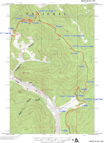 In this
before - after example, the new trail line is shown in red. The
old trail follows the Swan River. In one place, the old route is over 10,000
feet from the new one. The map includes annotations for
mileages and features along
the way. The coordinates of all these annotations may be exported to
nearly all makes of recreational grade GPS receivers. Unlike typical
positions scaled from where a trail is presumed to be located, these GPS
waypoints were all actually measured in the field. As a result, recreational grade GPS equipment will finally be a reliable means of navigating
confusing areas. This map shows the typical output from the Atlas pages of
the Colorado Trail CD. This map is designed to print on a standard sheet
of printer paper, but has been reduced somewhat for the website.
In this
before - after example, the new trail line is shown in red. The
old trail follows the Swan River. In one place, the old route is over 10,000
feet from the new one. The map includes annotations for
mileages and features along
the way. The coordinates of all these annotations may be exported to
nearly all makes of recreational grade GPS receivers. Unlike typical
positions scaled from where a trail is presumed to be located, these GPS
waypoints were all actually measured in the field. As a result, recreational grade GPS equipment will finally be a reliable means of navigating
confusing areas. This map shows the typical output from the Atlas pages of
the Colorado Trail CD. This map is designed to print on a standard sheet
of printer paper, but has been reduced somewhat for the website.
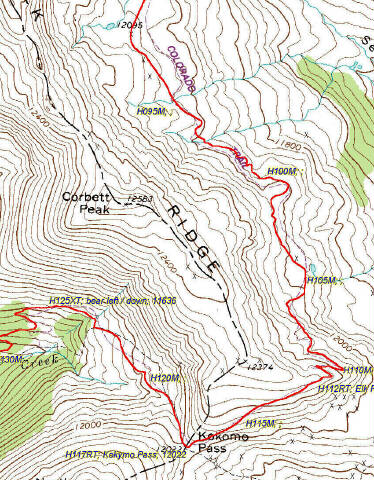
 This
is a small slice from a map showing the summit of Kokymo Pass between Copper Mountain
and Camp Hale, Colorado. This is a portion of Section 08 of the Colorado Trail. The
resolution of the maps is stunning, even at high magnification. Here
again, there is a discrepancy between where the trail was thought to be and
where it really is. Note the extra detail shown by the GPS track,
which defines every small twist and turn of the trail. Image
on the left is at 100% scale to show actual image quality.
This
is a small slice from a map showing the summit of Kokymo Pass between Copper Mountain
and Camp Hale, Colorado. This is a portion of Section 08 of the Colorado Trail. The
resolution of the maps is stunning, even at high magnification. Here
again, there is a discrepancy between where the trail was thought to be and
where it really is. Note the extra detail shown by the GPS track,
which defines every small twist and turn of the trail. Image
on the left is at 100% scale to show actual image quality.
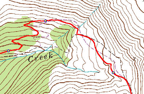
 This
is a slice of a map showing parts of Sections 1 and 2 of the Colorado Trail
without annotations. Incredible detail is possible with GPS. The
original maps showed little resolution. The GPS equipment used recorded a
position on one or five second intervals, with a position average of one
point every 6 feet. This was reduced to a more workable data set with
positions every 30 feet which were connected to draw the
alignment.
This
is a slice of a map showing parts of Sections 1 and 2 of the Colorado Trail
without annotations. Incredible detail is possible with GPS. The
original maps showed little resolution. The GPS equipment used recorded a
position on one or five second intervals, with a position average of one
point every 6 feet. This was reduced to a more workable data set with
positions every 30 feet which were connected to draw the
alignment.
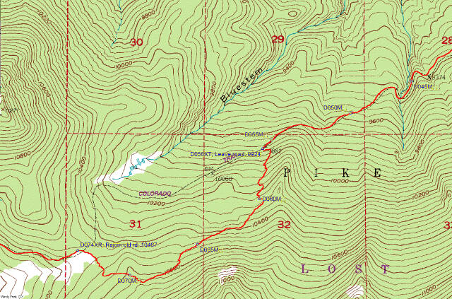 Here
is another before - after type map slice with the USGS map position of the trail
being over 3000 feet from where the route actually is today. The normal
method of scaling information from a topo could easily get people lost in
situations like this. There are numerous places like this along the
trail. Once a route is established, the maps rarely change. It's
nice to know where things really are.
Here
is another before - after type map slice with the USGS map position of the trail
being over 3000 feet from where the route actually is today. The normal
method of scaling information from a topo could easily get people lost in
situations like this. There are numerous places like this along the
trail. Once a route is established, the maps rarely change. It's
nice to know where things really are.
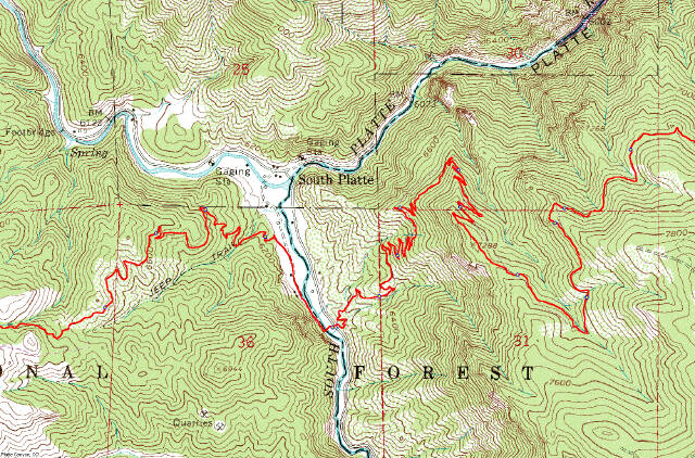
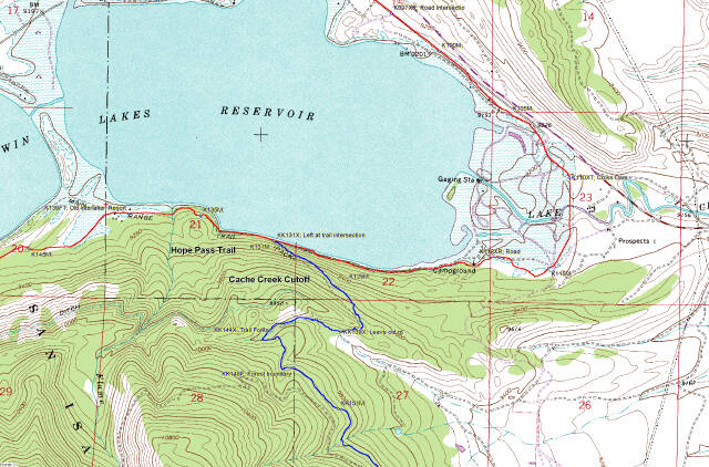 One
really nice thing about digital information is the ease at which it may be
updated. This map shows a recent realignment of the Colorado Trail.
The blue route is now the official one for through hikers and the old one has
become a spur. Changes such as these could take years without digital
data. Bear Creek will be updating changes to the Colorado Trail annually
so trail users can always have information less than 12 months old.
One
really nice thing about digital information is the ease at which it may be
updated. This map shows a recent realignment of the Colorado Trail.
The blue route is now the official one for through hikers and the old one has
become a spur. Changes such as these could take years without digital
data. Bear Creek will be updating changes to the Colorado Trail annually
so trail users can always have information less than 12 months old.
(click to enlarge)" align="left" width="151" height="100">This is a slice of a map showing parts of Sections 1 and 2 of the Colorado Trail without annotations. Incredible detail is possible with GPS. The original maps showed little resolution. The GPS equipment used recorded a position on one or five second intervals, with a position average of one point every 6 feet. This was reduced to a more workable data set with positions every 30 feet which were connected to draw the alignment.
Here
is another before - after type map slice with the USGS map position of the trail
being over 3000 feet from where the route actually is today. The normal
method of scaling information from a topo could easily get people lost in
situations like this. There are numerous places like this along the
trail. Once a route is established, the maps rarely change. It's
nice to know where things really are.
One
really nice thing about digital information is the ease at which it may be
updated. This map shows a recent realignment of the Colorado Trail.
The blue route is now the official one for through hikers and the old one has
become a spur. Changes such as these could take years without digital
data. Bear Creek will be updating changes to the Colorado Trail annually
so trail users can always have information less than 12 months old.