 Outpost
Wilderness Adventures, LLC
Outpost
Wilderness Adventures, LLC
Outpost
Wilderness Adventures, LLC
Join
March 3 - 17, 2007
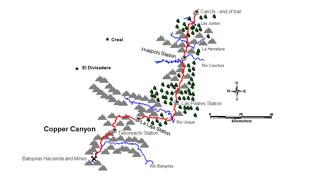
Copper Canyon
is spectacular! It is deeper
and larger than the
“The Trail at the End of the
World”
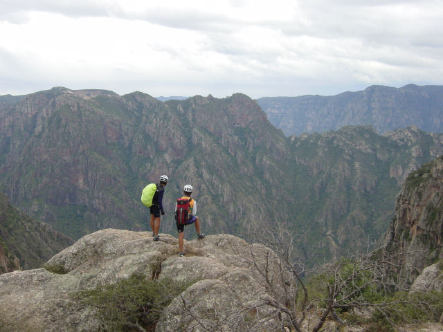
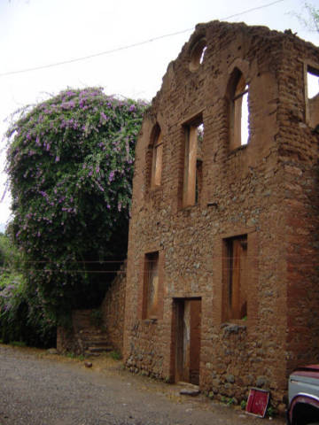
"Above the gorge" - photo from the 2004 joint Mexican / US exploration to re-locate the lost Silver Trail
After five years of planning,
exploring, mapping, and re-discovery, we are offering the first ever through trek of the fabled "Ruta de los
Conductores", more commonly referred to as the "Mexico Silver
Trail". This trail was used until 1918 to transport silver and
supplies between the towns of Carichic and the silver mines at Batopilas,
located in the bottom of the fabled Barranca
de Cobre, or
9 days of hiking – 103 miles total distance
 Click on thumbnails to see any image
Day 1: Arrive at the Chihuahua City airport where you will be met by a guide and a van. Travel to a motel and spend the night.
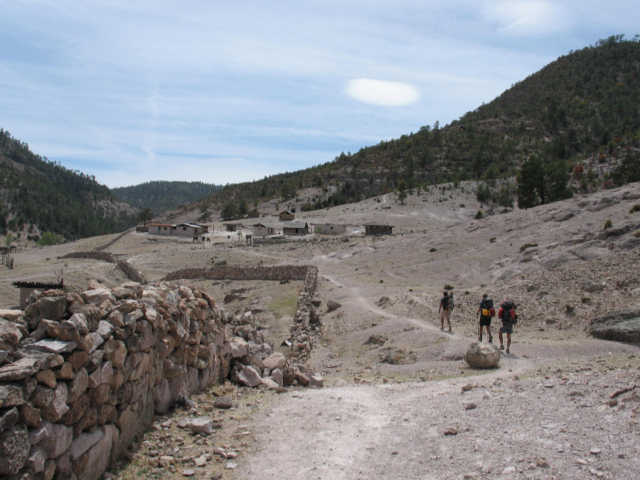
Day 2: Transfer to the beginning of the Silver Trail in Carachi. View the ruins of the old stage station where the conductas (mule trains) exchanged silver bullion for supplies before returning into the canyon. Drive along the Silver Trail to the end of the road at El Ojito and hike about 5.7 miles to our campsite on the Hojaschi, a tributary of the Rio Conchos. Our campsite is by the ruins of an abandoned ranchera deep in Rarámuri country.
.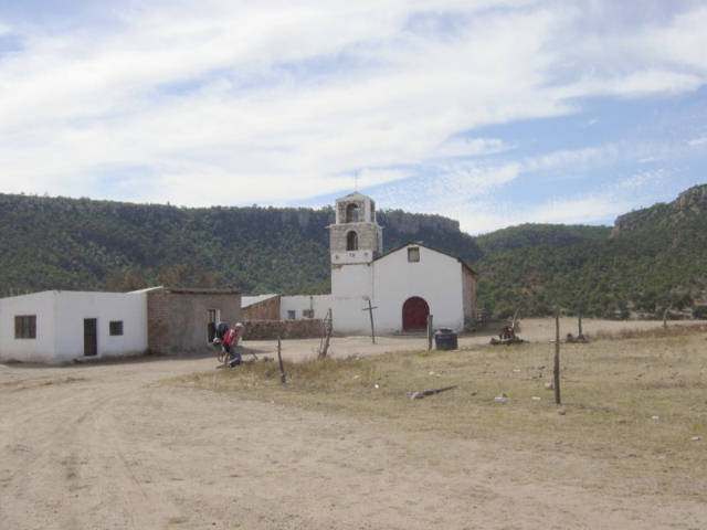 Baquiriachi is the last accessible village for
several days. The hike begins nearby.
Baquiriachi is the last accessible village for
several days. The hike begins nearby.
Day 3: Start early and hike to Huajochi, the site of one of the Batopilas Mining Corporations old way stations. Take a look at the station and (hopefully) visit with some Tarahuamara farmers who live at the tiny ranchera of Huajochi on the banks of the Rio Conchos. On our first expedition to locate the trail, these fine people provided us with shelter, pinole (a local concoction used as an energy food), eggs, and tortillas to subsidize our dwindling food supplies. After lunch in Huajochi, climb out of the canyon via a steep, secretive trail to the mesa above and cross the mesa to the next drainage, where another Rarámuri ranchera known to us as Nacho Kino's is passed. Climb another steep section to a hidden spring located near the trail. Here we will camp. Distance for the day: 11.8 miles.
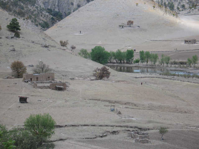 The way station at Huajochi
Day 4: Hike from the hidden springs into the valley of the Rio Cicochi then
turn and follow the Rio Agua Caliente. Follow the river
up past occupied cave homes and several small rancheras and camp at a hot springs.
Bathe and soak in the springs. Hike distance for day is 8.2 miles.
 A ranchera along the Rio Agua Caliente
Day 5: Leave the hot springs and continue up the beautiful valley. Eventually leave the valley and climb up to where the trail has been developed into a jeep trail by loggers. Follow the logging trail to the ruins of the way station known as Las Pilares where we will meet the van and camp. Hiking distance for the day is 11.7 miles.
Day 6: Hike to the village of Siquirichi . Much of this days hike follows a logging trail built over the original Silver Trail through pine forests. Cross the Rio Urique on a long suspension bridge and hike past the village to a van supported campsite. Hiking distance for day: 9.6 miles
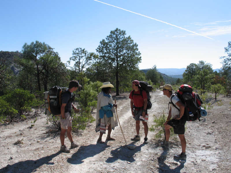 Our group has a discussion with a local elder
Day 7: Drop into a remarkable canyon, cross, and climb up to the mesa beyond. Hike past the small ranchera of Huizaroche and camp along a stream. Hiking distance for day: 13.2 miles.
Day 8: Hike to the La Laja way station where we will meet the van. Visit the way station then pile into the van for a short ride to avoid a section of trail that lies under the highway. Leave the van and hike into the remarkable Arroyo Samachique, a canyon featuring ancient cave homes. Camp along a small river in the canyon. Total hiking distance for day: 8.5 miles.
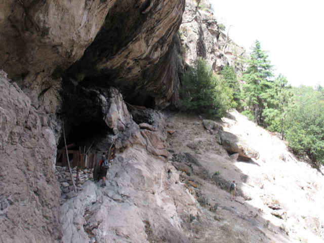 A cave home near the Arroyo Samachique
Day 9: Leave the canyon and climb up to a high ridge. Follow the ridge as it drops down towards the inner gorge of Copper Canyon. Camp at the remote way station of Teboreachi along a small stream. This is the last way station before entering the inner gorge. Total distance hiked for day: 10.4 miles.
Day 10: Descend carefully into the inner canyon. Slowly leave the pine forests behind and enter a more desert like environment. Hike to Coyochique, a small ranchera perched above the inner canyon.
Day 11: Hike from Coyochique to Batopilas. Look at the old mission of Potrero along the Batopilas River. Hike along the river through giant stands of Pithya cactus. Arrive at Batopilas where we will spend the night in an old but elegant hotel. Hiking distance for day: 12.7 miles.
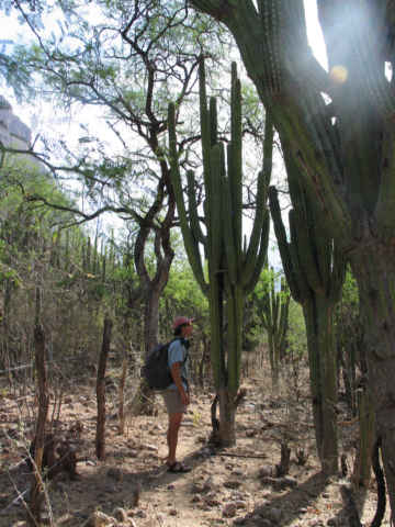 Pithya along the way
Day 12: See sights around Batopilas, including the old hacienda that was the headquarters for the Batopilas Mining Company. Leave the canyon via van and travel to Cusarare. Spend the night in a beautiful log lodge near Cusarare Falls.
 The ruins of the Batopillas Mining Company
hacienda
The ruins of the Batopillas Mining Company
hacienda 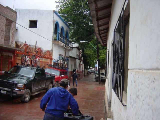 Batopilas street
Day 13: Travel from Creel to Chihuahua City. Spend the night in the old downtown section of Chihuahua City seeing some of the sights, including the old hacienda of Pancho Villa.
Day 14: Fly home.
The cost for the trip is $1950, and includes all accommodations, ground transportation, food, etc. Hotel / Motel accommodations assume double occupancy. Air fare to / from Chihuahua is not included.
Participants should be in reasonably good physical shape. Good, supportive footgear is recommended. The trail is rough in many places after nearly a century of abandonment. The daily hiking distances are not particularly long, however, and some days are short due to logistical considerations. The area is quite vast and largely roadless. There will be two trekking sections that will require three nights out until a re-supply point is reached. Participants should have good, lightweight backpacking equipment including tents, sleeping bags, pads, and rain gear. We may be able to provide some gear for those who need it. The itinerary is subject to minor modifications depending upon weather, strength of group, or other circumstances. We will provide a detailed list of what you need to bring well in advance of starting the trek.
A bit about the Rarámuri
Historically, the Rarámuri are a bit of a mystery. They are generally regarded to be descendants of the Paquime civilization, which farmed and traded from Chaco Canyon, New Mexico southward throughout the Sierra Madre Occidental of Mexico. No written history exists prior to the early 1600's, when Jesuit missionaries moved to the area. Many similarities exist between the Paquime civilization and the Ancient Puebloans of the southwestern US. Both civilizations commonly lived in cliff dwellings and farmed the small valleys below. Both cultures peaked and then declined in the 14th century.
One thing we do know, the Rarámuri are famous for their abilities as runners. In 1993 and 1994, Rarámuri runners won the Leadville 100, running in huaraches. The winner was 55 years old. We learned early on in our explorations to appreciate this. When we asked how far it was to a certain destination, we would invariably get answers like 4 hours, or a day. Oftentimes the four hour sections would take us a long, hard day, and the day sections would take at least two. These people move fast. There is a fascinating paper written about this that is available online at http://www.lehigh.edu/dmd1/public/www-data/art.html .
The Rarámuri are generally very friendly and helpful. However, when we first mapped the Silver Trail in 2004 we met some who had never encountered anglos before, and in our mountain biking regalia we were quite a disturbance. In the ensuing trips, we have been met with warm welcomes as they have slowly gotten to know us. A few rules apply here, though. You should never take a photo of someone without asking permission first. Most will quickly agree to allow it, but remember to ask. Not all of the Rarámuri speak Spanish, many only know the native Rarámuri Language. Remember this when trying to communicate.
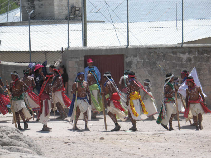 Celebration of Semana Santa in a Rarámuri village

The Rarámuri are agricultural. They farm small plots wherever there is water and suitable soil. Crops include corn, beans, squash, and potatoes. They also collect naturally occurring foods such as cactus, nuts, and berries. The villages are referred to as rancheras. Most villages have pigs, goats, sheep, and chickens. The farms are run by collectives of just a few families who farm cooperatively.
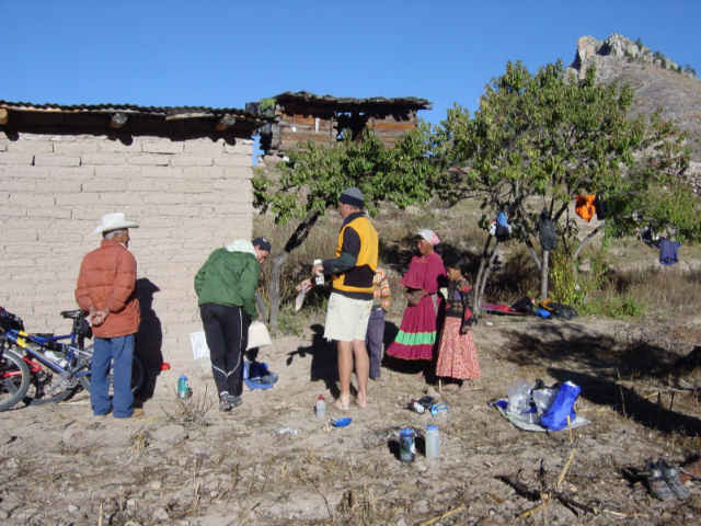 Sr. Flores and family, Huajochi
The Rarámuri infant mortality rate (95 per 1000 live births) is nearly double that of the Mexico national indigenous infant mortality rate (55 x 1000) and nearly triple that of the national infant mortality rate (35 per 1000) (Fernández, 1990; Gómez de León, 1992). This is due primarily to impure water leading to diarrhea and starvation during times of drought. This is much better than a few decades ago, when infant mortality was greater than 50%.
To sign up, or for more information contact:
OWA (click here to visit the OWA web site)
(P) 830-825-3015
(F) 830-825-3116
email: http://www.owa.com/email.cfm
or:
Jerry Brown
3065 East 2nd Ave
Durango, CO 81301
(970) 247-0824 (970) 749-0496
toll free: (888) 247-0824
email: bearcreek@wic.net
For some history and lots of good photos click here: Silver Trail Info and Photos
Creel Weather report is here: